|

|
 Kayak the Langu Khola, Part II Grant Recipients Run River in Nepal [Page I] [Page II] [Page III] [Dagger Endurance Grant]
We made our way through the class III and IV whitewater, eddy hopping, exhilarated by the river. In an unassuming spot I heard a whistle blast. Instinctively I caught the first eddy and looked around for the other members. Paul and Kurt were eddied out downstream and Dave upstream. Andy tottered down the shore to Dave and then to me. "I broke my boat," was all he said.* "How?" was all I asked. "I must have landed on a sharp rock because it's a long gash," he said. We gathered everyone by the boat and sure enough there was a 25-centimeter gash under the pillar near the stern. Andy was understandably upset, but we decided to lighten his boat, tape the crack, and camp as soon as possible. We found a goat herder's camp on a plateau just downstream and set up to fix the boat. After several hours of planning, preparing, and repairing we had completed our first field patch which consisted of plastic weld, Shoe Goo, and a liberal amount of duct tape. It looked good and I thought, barring any direct blows, it would hold. The question was for how long. We made camp in an area sheltered by a rock band. As I lay in my tent, I hoped the next 5,000 kilometers would go smoother than the last 10. Early the next morning, we passed the town of Shimen. Willow trees grew amongst the stone houses which were dispersed between fields of buckwheat. A few of the locals stopped thrashing grain long enough to greet us and some of the children followed us back to our boats. After a short Frisbee demonstration we were off.
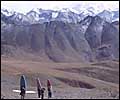
The next town was Nissal, but between Shimen and Nissal the river ran though a deep gorge. David Snellgrove, a British scholar of Tibetan Buddhism who explored Inner Dolpo, referred to this section of river as an "impassable gorge." Both to ease the tension the phrase brought and to reflect our limited knowledge of the river we had been calling it "the first impassable gorge." The trail from Shimen to Nissal climbs up over 17,000 feet and then drops down to Nissal at near 13,000 feet. I couldn't help but wonder what type of gorge would make people traverse 8,000-vertical feet to avoid it. We floated down and watched as the valley walls grew steeper and closed in. The lowest part of the canyon was steep, but above it there were lots of benches which offered escape routes. The whitewater became increasingly difficult and, staying in our boats, we progressed from eddy to eddy. When the route was not obvious, the first boater would get out and explain the line to the others. Eventually we came upon a boulder-choked section that barely allowed the water through. Our portage route wandered though the landslide on the riverbank. The river twisted and turned as it made its way through the narrow gorge and after eight kilometers of class IV/V whitewater, the rapids eased up and we all started to smile. Our delight didn't last long — a few turns later we reached a vertical walled section. Climbing out of the canyon had not been an option, but up until this point we could have traveled back upstream on benches above the river. Below us the walls were only 100 to 200 feet tall, but they prevented us from climbing out. The group gathered at our last possible escape route to discuss our next move.
We followed as the river twisted along the cliffs. The whitewater was mild with one portage. We passed herds of yaks and bearded vultures on the cliffs before the walls suddenly opened. We had made it to Nissal and we were ecstatic to be there. From the maps and our altimeter, we figured the gradient in the gorge was 11m/km, but between its pool-drop nature and the flat water at the end, it was fairly exciting. The patch on Andy's boat had failed just before camp and he began what was to be a daily ritual of fixing it. The valley was quite open below Nissal, and we could see the glaciated peaks that form the eastside of the Kanjiroba Himal. Looking downstream, the river meandered through mostly class III whitewater. High on the hillside above the river stood Yasher Gompa, an ancient holy site for Tibetan Buddhists. Forty years before, Snellgove had documented the features of this compound and, with his notes in hand, we took a tour of the site. From the gompa, the view of the gorge we had just traversed was very impressive. The jagged mountain ridges dropped menacingly down to the river. I was very glad that we had made it through, and equally glad that I had not seen this view before we entered. That night we celebrated the end of our week above 4000 meters and Kurt set a personal goal of sleeping the entire night without a hat (though it would be a few more nights before he would reach it). The next morning we passed the confluence of the Panjang and Nangung rivers a few kilometers downstream. The Nangung flows from the town of Saldang to join the Panjang and together they form the Langu. After 10 days of walking and three days of boating we had reached the Langu. We stopped at an abandoned village for lunch where in the past a large landslide roared down from a north-side drainage. Kurt hypothesized that it had covered the local spring and forced the village residents to move on. It had been a very relaxing day so far. "If it keeps up like this," Andy said, "we could be at the Tar Khola tomorrow." We hopped into our boats ready to race to the Tar. Around the corner, a hypnotic gray slope marked the entrance to the next set of rapids. Before lunch it had been class III between sloping dry valley walls. After our break, the rock turned black and we bopped down through a long IV. There were a lot of landslides and the water churned around the rock debris piles. Andy tipped over in a particularly turbulent slot and tore his spray skirt. This provided a convenient excuse to get out and scout. As Andy repaired the skirt, Kurt and I peered down into the next class V. The lead-in was all white except for all the rocks that blocked the "clean" line into the large hole at the bottom. Just to make things more interesting, the right side of the hydraulic fed into a nice eddy, while the left side flushed under a really big pile of rocks. "Bash down the center left and hit the hole at the bottom hard with some right angle" was the advice I gave Paul. He had a good run from my instructions, while I bounced off a rock just above the hole and side-surfed my way into the eddy. There were several large rapids in this section and with the nearly constant cascade of rocks from above it was easy to see how they had formed. While scouting one long technical series of drops, I became engrossed in planning my line through the rapid. The rest of the group spread along the bank with throw bags and cameras and watched in disbelief as I got in my boat and pushed off, oblivious to a landslide tumbling down above. Fortunately it did not reach the river. We portaged a very long rapid which contained "too many consequences" and camped at the first inviting beach we found. The canyon took on an orange hue in the afternoon light. One-by-one we ventured downstream to see what was next. A few hundred meters away a tributary poured out of a slot in the canyon wall. We lay on a large boulder and stared at our surroundings. I became fixated by the bearded vultures circling near the top of the canyon walls 2,000 feet above us. Kurt had told me these scavengers often grew to have a three-meter wing span and could fly away with a small sheep in their talons. "I think those vultures are following us," I told Paul. "They're not stupid," he replied, and we both laughed nervously. The next morning the class IV whitewater allowed us to enjoy the incredible canyon we were traversing. By midmorning, we arrived in the village of Kowagon. The location of the town was incorrect on our maps so we were as surprised to see the villagers there as they were to see us. Kowagon lies at the confluence of a tributary and the canyon walls opened just before we reached the village. It had been a dark and cold morning at the bottom of the gorge above, so we relaxed in the sunshine and played Frisbee with some of the locals. Below Kowagon we stopped for lunch on a large sandbar and tried to soak in as much sunshine as possible. Downstream, the mountainsides pinched together and it looked cold. Shortly after lunch, the walls closed in again as we entered another section where flat water drifted between vertical cliffs rising directly out of the river. We stopped to discuss our next move. The vertical section of the walls was only a few hundred feet tall, but above that they continued to jut upwards for as far as we could see. Since walking around to scout would take at least a week, we elected to explore by river. So far, where there had been no riverbank, the water was gentle and we all hoped this trend would continue. As we drifted down between the cliffs that allowed no escape, we giggled at our predicament. Silently I mused, "As long as we don't lose our sense of humor, things will be okay." A riverbank fortuitously reappeared as the river grew steeper and the whitewater increased. The rapids became bigger and more technical as we continued, but we hoped the Tar Khola was close. It was getting late and we were getting tired, but the idea of reaching the next landmark kept us going. Around a bend the walls pinched in and the river dropped out of sight. Each of our intentions then became evident as the group split in two; Paul and Kurt cautiously approached the horizon line while the rest of us began looking for a camp. They reported that the rapid was too big to be dealt with that evening, so we all camped in a grove of cottonwoods. I was tired and cold and couldn't wait to get out of my river gear. Kurt and Paul felt that the rapid we camped above could be portaged on the right side. We all walked downstream to take a look. The cascade was truly impressive, filled with house-sized limestone boulders. The water surged in and around the boulders. I thought I saw a clean line until the water dove under a large rock. Near the bottom of the rapid, the river went into yet another vertically-walled gorge. Within the walls the cascade ended in a pool before the next rapid started. As the river entered the gorge it made a hard right turn. About 25 meters above the water level there was a large cave. The cliff walls were also limestone and the sides of the cave were smooth and polished. The high water mark towered above us and we figured the tremendous force of the river had carved the cave out as it piled up against the cliffs.
After a few upstream ferries Kurt chose a slot and proceeded through safely. We followed one at a time. The rapid was class IV, but the water was very squirrelly as it pushed between the rocks towering above our heads. In the middle of this rapid I became stuck on a partially submerged rock. Though my predicament was fairly inconsequential, as I made big sweeping motions with my upstream blade, I realized that no rescue would be possible. We made our way down through the next set of class V rapids and through another vertical-walled class III section. At the confluence of the Tar Khola we stopped to enjoy the view. Hoping to reach this point by day three, we had finally reached the confluence on the morning of day six. At the mouth of the Kanjiroba Khola we decided to camp early and spend the afternoon hiking. Bharal Sheep roamed the steep hillsides that rose abruptly into the snow capped flanks of Karo Himal. We arose early from our camp in the deep grass and were well rested and with renewed spirit. Once on the river, we passed a tight drainage on the south before the river dropped into a big canyon. The largest walls we had seen thus far loomed above us, blocking the view of the 22,000-foot peaks on either side of us. The river ran smoothly through slots less than a boat-length wide, splitting rock slabs whose tops lay more than 60 feet above us. Around a tight corner the river ran into a huge dirt dam. The pile of debris rose 500 feet and blocked nearly the entire river channel. An open slot on the right was blocked by boulders and logs at the bottom. This pile of rock and wood was over 20-meters high. Andy climbed up to investigate. "I don't want to haul my boat over that thing," Dave sighed while looking up at the dam. We gaped up at the chasm which surrounded us waiting for the verdict from Andy. "It goes at river level," he called back. "Downstream, the walls drop straight into the river. The water is flat as far as I can see." "How far is that?" Paul wanted to know. "About 300 feet until the first turn, and the walls don't let up." We elected to send part of the group through the crevice at the pile's bottom. If they did not like what they found on the other side, the remaining three could facilitate a rescue. Paul and Kurt followed me as I headed down towards the dam. The river flowed under the rocks leaving a tunnel about four feet wide and two feet high. I laid my paddle parallel to my boat and leaned forward. The boat followed the water wriggling through the gap for about 15 feet before reaching the other side. We emerged into a rock-walled amphitheater. Kurt hugged the wall while I looked around the corner. "It keeps going like this for as far as I can see," I called back. The others came through and we drifted between the enormous walls. The walls backed off a bit, but it still felt like we were living in the bottom of a crack. The river twisted between rock outcroppings and boulders that towered over our heads. It began to drop more quickly and became more difficult before curling up into a hole under a building-sized rock. We portaged down the left side and lined our boats below the hole. Working as a team it took us an hour to travel 500 feet downstream. Hauling our boats amidst the car-sized boulders that made up the bank was exhausting and the river was still class V below. At the end of the portage I pounded another PowerGel and got back into my boat.
* Dagger boats are known for their durability and are expedition-proven worldwide, but unfortunately for Andy's boat, age and the many previous years of storage in the sun were all that she could
take. |
||||||||||||||||||||||||