
Scientists Ponder Revision in Height
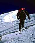
The expedition, sponsored by Boston's Museum of Science and partially by The National Geographic Society, was wholly oriented to making scientific measurements on the mountain. When expedition leader Wally Berg reached the summit on May 20, one of his primary mandates from the scientists was to mount a GPS receiver firmly in the highest solid bedrock on the summit. That point is the Barry Bishop Ledge, so named because it is the same rock outcrop visible in the famous 1963 photograph of Lute Jerstad taken by Barry Bishop near the summit, with the American flag visible. For several years this outcrop was referred to as Barry Bishop Rock, but at the suggestions of the Museum of Science's Brad Washburn, the name has been revised to Barry Bishop Ledge to more accurately reflect its nature.
In fact, one result of their scientific studies last spring was to come away impressed by the work of their 1950's Indian counterparts. "You have to be impressed," said Mencin, "that with all our satellite measuring systems and other advantages, our numbers are still within 10 meters of Gulatee's 1954 survey." "It's a classic work," concurs Corfield, "and sets a high standard to follow."
"However, the height we have measured for the Bishop Ledge suggests that the official height of the mountain itself may well need to be revisited. "Our figures from this spring, which I will round to the nearest 10m for simplicity, are as follows: after corrections for geoid (see editor's note below) Bishop Ledge was measured at 8,810 meters.
Dave Mencin added, "The thing I think we need to point out is that the largest probable error in these computations is our 'guess' at the vertical separation between Bishop Ledge and the snow summit." Even so, both scientists think that some revision in the altitude of Mount Everest is required, but not necessarily to any significant effect. "To dispel any doubts," cautioned Corfield, "Everest remains the tallest mountain by a wide margin. K2, the second highest mountain in the world, has been measured at 28,250 feet." But a new "official" height of Mount Everest might in fact mean that no mountain on earth is higher than 29,000 feet. — Peter Potterfield, Mountain Zone Staff
Editor's Note: Readers should understand that modern surveyors use
geoid and ellipsoid models to measure high mountains. Those are
complicated concepts, but the technically inclined should [click here for
Dave Mencin's and Charles Corfield's explanation] of these models, and on
the methodology of last spring's measurements.
| ||||||||||||||||||||||||||||||
[Everest '98] [More Climbing Stories] [MountainZone.com Home]