|


|
 |
Mount Rainier National Park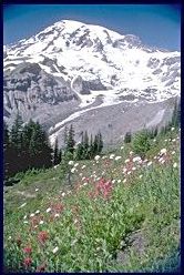
Mount Rainier has the greatest single-peak glacial system in the United States, which radiates from the summit and slopes of the
14,411 foot dormant volcano. The park, which was established on March 2, 1899, contains vast expanses of pristine old growth forests, subalpine flower meadows, spectacular alpine scenery, and stimulating outdoor activities. Mount Rainier National Park is the fifth oldest national park in the United States. The first recorded view of Mount Rainier was made by Captain George Vancouver while mapping Puget Sound in 1792. Mount Rainier is a volcano that is believed to be dormant and not extinct. The volcano began to grow between one half and one million years ago. The slopes of lava flows on opposite sides of the mountain projected more than 1,000 feet above the present summit. The upper portion of the cone was probably removed by explosions and landslides. The current summit, Columbia Crest at 14,411 feet, lies on the rim of the recent lava cone. The park encompasses 378 square miles (980 square kilometers, 235.612.5 acres). Elevation ranges from 1,880 at the Carbon River rain forest (NW corner of park) to 14,411 feet at the summit.
|