|
New Official Height for Everest
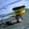
The revised elevation — 29,035 feet (8850 meters), two meters or seven feet higher than the previously accepted figure — was announced Nov. 11 by Bradford Washburn, renowned mountain photographer/explorer and honorary director of Boston's Museum of Science, at the opening reception of the 87th annual meeting of the American Alpine Club. The event, held at National Geographic Society headquarters in Washington, was attended by a large number of America's top Everest climbers and experts, and included a presentation by Eric Simonson and Conrad Anker of last spring's Mallory & Irvine Research Expedition. "National Geographic is accepting this new elevation for Everest because it is clearly the most authoritative and thoroughly executed measurement of the highest point on the Earth's surface," said Allen Carroll, the Society's chief cartographer. "As always, National Geographic goes with the best sources." Everest's new elevation is remarkably close to the previous official height of 29,028 feet (8848 meters) set in 1954 by the Survey of India after picking the unweighted mean of altitudes determined from 12 different survey stations around the mountain. The observations made in 1954 varied by 17 feet; the margin of error in the 1999 calculation was only a fraction of that. Washburn said the latest data had been received "with enthusiastic approval" by the U.S. National Imagery and Mapping Agency and China's National Bureau of Surveying and Mapping. "Our data for the altitude and position of Everest are based on precise observations made on May 5, 1999, for a total of 50 minutes," Washburn said. This latest measurement stemmed from Washburn's interest in 1995 to use lightweight Trimble GPS receivers, along with lithium batteries that work in temperatures as low as 40 below, to establish the highest bedrock survey station in the world on Everest's 26,000-foot South Col. Then, running two receivers simultaneously, one at the South Col and the other at the summit, an extremely accurate altitude could be established for the top of the mountain. Mountaineers Pete Athans and Bill Crouse of the Everest Millennium Expedition reached the summit on May 5 with five Sherpas. "We climbed through the night so that we could be on top of the mountain to work in the warmest part of the day," said Athans, a climber who holds the record as the only Westerner who has reached Everest's summit six times. "It was pleasant on top of the world that morning, just a little wind and 12°F below. The equipment worked without a problem." The GPS equipment was carried by two Sherpas on the team. Once in place, at the very top of the mountain, it was able to receive signals from GPS satellites. Running in tandem with the receiver at 26,000 feet on the South Col, the receiver on the summit was able to give an exact altitude and position for the top of Everest. Washburn said the reading of 29,035 feet showed no measurable change in the height of Everest calculated since GPS observations began at the South Col four years ago. But from GPS readings from the South Col over the past four years, with the receiver being attached to the same steel bolt fixed permanently into the rock face, it appears that the horizontal position of Everest seems to be moving steadily and slightly northeastward — about 6cm a year. "At this moment, six months after we made our measurement, Everest is already almost certainly located slightly northeast of the position that it occupied in May," he said. Washburn said that the figures could also change as the great fault system continues to shove India under Nepal and China, creating the Himalaya. Calculating the revised elevation of Everest involved Roger Bilham of the University of Colorado, Boulder, two of his students, David Mencin and Frederick Blume, and Kristine Larson, of the aerospace engineering sciences department of the University of Colorado. Charles Corfield of Palo Alto, Calif., was the science manager of the last two Washburn expeditions to Everest. (click for Everest '97, Everest '98 and Everest '99 for the full stories—complete with live dispatches—from all three of these expeditions). Also working closely with this team were two world leaders in the field of Himalayan geodesy: Muneendra Kumar of the National Imagery and Mapping Agency (NIMA) of the United States and Jun Yong Chen, senior advisor to the National Bureau of Surveying and Mapping of China. Washburn, 89, is an honorary member of the American Alpine Club. (Click for the full video interview with Brad Washburn) as he describes the science that led to this revised height). He began his mountaineering career in his teens, climbing the loftiest Alps. In 1935 he led a National Geographic Society-sponsored expedition that recorded 6,000 square miles of Canada's Yukon Territory, an area previously blank on the world's maps. With his wife, Barbara, in cooperation with the Society and Swissair Photo Surveys of Zurich, he produced in 1988 the most detailed and accurate map ever made of Mount Everest. — MountainZone.com Staff
|
||||