
June 6, 2000

| »Home »Updates »Photos »Route Map »Sponsors |
|||||
Day 87, Mile 490
Well, we managed to get to the next resupply stop without any trouble. But man have things changed since then. We've gone from 9,000 feet, with the trout and bears, to 4,500 feet on the floor of the desert. In three weeks the temperature at sunset has risen over 60 degrees Fahrenheit. What a land of extremes! Yesterday it was 102 degrees Fahrenheit yet we can still see the cool, pine-covered Boulder Mountain.
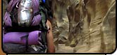
| "We enjoyed our last cool nights and days up there before following Pleasant Creek down into the inferno at Capitol Reef National Park." |
After leaving Posy Lake, our last resupply, our friends came with us into the Box-Death Hollow Wilderness. We spent three days with them hiking, lounging, and fishing.
From there it was back into the high country for us. We crossed Boulder Mountain and at over 11,000 feet — we're at the greatest elevation of this journey. We enjoyed our last cool nights and days up there before following Pleasant Creek down into the inferno at Capitol Reef National Park. And Pleasant Creek was so aptly named.
At its origins, high in a beautiful elk pasture, is merely a trickle. But it soon gains volume after plunging off the mountain. Then it becomes a trout stream as it courses along beneath the aspens and firs. We watched it get bigger still as we followed it down through the ponderosas then the piñon-juniper forest, And then, quite suddenly, it led us into the deep, sandstone canyons that it has carved right through the tilted and crazy ridge of Capitol Reef. And finally its waters warmed and filled with silt and we walked right in the stream as we followed it out into the hard desert of the Water Pocket Fold. Out into the sun and heat.
|
|
So instead of walking past the Fremont River and out into the San Rafeal Desert, we turned it to the east and followed the river into Hanksvile. From there we are back on our planned route and will shorten and combine our last two sections. We will leave with a 14-day lead and should be able to find enough water to get us all the way to our goal: Arches National Park.
Well the next letter we mail to you will be from home, as long as everything goes well. I'm sure it will. So, until next time!
— Joe "Mitch" Mitchell and Mike Coronella, MountainZone.com Correspondents
| EXPEDITION DISPATCHES | |
|
|